The Wayƒarers Journal ©

The Journal

The Wayƒarers

The Selƒ

The Journey

The Burden

The Mountain

   The Ancients
   The Earth

     Geochronology
     Continents

       Africa
       Antarctica
       Asia
       Europe
       North America

         Geographical

           Arctic Mtns
           Greenland Isl
           CAN Lowlands
           CAN Shield
           Int. Lowlands
           Rocky Mtns
           Basin-Range
           Pacific Coast
           Great Plains
           Appalachian
           Int. Highland
           Coastal Plains
           N. Sierra Mad.
           Volcanic Mtns
           S. Sierra Mad.
           S. M. de Chipas
           S. Pacific Cst
           Island Lands
           Continent Shelf

         Geological

       Oceania
       South America

     Oceans

   The Life
   The Modern Man
   The Nonpareils
   The Steps
   The Way

The Appendix

The Wayƒarer
The Mountain
Go to bottom of this page
THE GEOGRAPHICAL REGIONS
The Pacific Coast Ranges

The Sierra Nevada Mountains Ecoregion Go Down Go Back
The Sierra Nevada is a mountain range in the Western United States, between the Central Valley of California just to the west and the Basin and Range region to the east. The vast majority of the range lies in the state of California, although the Carson Range spur lies primarily in Nevada.
Its magnificent skyline and spectacular landscapes make it one of the most beautiful physical features of the United States. It is home to the largest trees, the giant sequoias as well as the oldest non clonal trees, the bristle cone pine, making the Sierra Nevada range biologically important.

Geology
The Sierra Nevada is an upfaulted, tilted block of the Earth′s crust. A major fault zone bounds the block on the east, and it was along this that the great mass that became the Sierra Nevada was uplifted and tilted westward. This explains the asymmetry of the range. As the block was uplifted, the abrupt, east-facing escarpment was cut into by the erosive action of wind, rain, temperature change, frost, and ice, and a series of steep-gradient canyons developed.
The western sides is a more gently slope and streams flow more gently down the geologic dip slope, creating massive alluvial fans that encroach into the Central Valley of California.
It is believed that the massive uplift began many millions of years ago but that much of it occurred in the past two million years. The present-day relief of 10,000 to 11,000 feet along the eastern slopes in the southern Sierra Nevada attests to the tremendous uplift.

Physical Geography
The Sierra Nevada is an asymmetrical range with its crest and high peaks notably toward the east. The high peaks range from 11,000 to 14,000 feet above sea level, with Mount Whitney, the highest peak in the contiguous United States, at 14,494 feet.
Summits in the northern section of the range, above Lake Tahoe are much lower, reaching altitudes of only 7,000 to 9,000 feet.
This range extends more than 250 miles northward from the Mojave Desert to the Cascade Range of northern California and Oregon. The width varies from about 80 miles wide at Lake Tahoe to about 50 miles wide in the south.

Ancient Steps:
Uto-Aztecan Numic Family Groups

Campgrounds:

Land forms:
Sierra Nevada Mountains
Prominent Mountains
Bald Eagle Mountain (7,183 feet); Kettle Rock (7,820 feet); Smith Peak (7,693 feet); Bunker Hill (6,967 feet); Sardine Peak (8,134 feet); Mokelumne Peak (9,334 feet); Eagle Peak (11,845 feet); Petit Peak (10,788 feet); Glass Mountain (11,123 feet); Red Slate Mountain (13,163 feet);
White Mountain (White Mountains) (14,246 feet); Mount Morgan (John Muir Wilderness) (13,005 feet); Mount Darwin (13,830 feet); Mount Woodworth (12,219 feet); Mount Whitney (14,494 feet); Sherman Peak (9,909 feet); Sugarloaf Mountain (6,244 feet)

Parks:
Kings Canyon national park
Sequoia national park
Manzanar National Historic Site

Sites:
Alabama Hills BLM
Owens River Valley

Pathway Journeys:
Footpath Journeys
Roadpath Journeys

The 2022 Journey, Sierra Nevada Mountain Go Down Go Up
Monday, 31 October 2022, Gardnerville, NV.
(Day 532 TN) 29°F. 6:00 am, sunny
Journey On, Day 31
Awake early, dress in my winter blues, walk inside the w-mart, purchase a large coffee, then return to the jammer and start the engine. Since it is so cold outside, I don a pair of socks, my gloves and my sweater cap to stay warm. I do this because the jammer, for some reason unknown to me lost the ability to blow hot air when the heater is on; it only blows cold air now.
I leave out of the parking lot, turn left on US 395 and continue my journey south for another twenty miles before I reach the California state line at which time, I continue into this state with a nearly full take of fuel, hoping not to have to pay the much higher prices within. (While here, I see prices over seven dollars per gallon; I have been paying just over five dollars in Oregon and less than five dollars in Washington.) I continue on US 395 which skirts the eastern edge of the Sierra Nevada Mountains, borders the Central Basin to the east and the valley that I am traversing southward is called the Owens Valley.

The 2017 Journey, Sierra Nevada Range Go Down Go Up
The Central Sierra Nevada
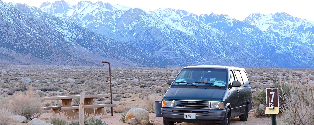
Also know as the High Sierras, this area of the range includes Mount Whitney, the tallest mountain in the Sierra Nevada as well as the tallest in the contiguous forty-eight.
The Sierra Nevada Mountain
The High Sierras
(m2cont-nam-geog-08-ca-8n-2017-0309.1746) Tuttle Creek Campground, Under the High Sierra Nevada
The Sierra Nevada Mountain
The High Sierras
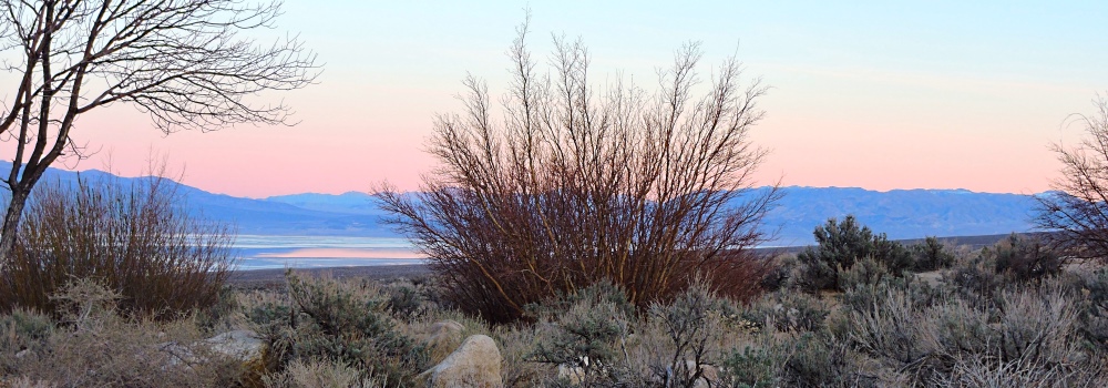
(m2cont-nam-geog-08-ca-8n-2017-0309.1747) Sunglow view Eastward of the Owens Valley

To go back to the Gallery Index, click on down arrow. Go Back Go to previous section
on this page

Thank you for visiting The Wayƒarers Journal.

See Ya above the Treeline!

This Page Last Updated: 30 June 2026


To continue to the next Episode Level page, Click here go to top
 
The Wayƒarers Journal © ::: Come Join the Journey ™
by Thom Buras
Come Join the Journey ™