The Wayƒarers Journal ©

The Journal

The Wayƒarers

The Selƒ

The Journey

The Burden

The Mountain

   The Ancients
   The Earth
   The Life
   The Modern Man
   The Nonpareils
   The Steps

     Steps Afoot

      Appalachian

        Maine
        New Hampshire
        Vermont
        Massachusetts
        Connecticut
        New York
        New Jersey
        Pennsylvania
        Maryland
        West Virginia
        Virginia
        Tennessee
        NC-TN
        North Carolina
        Georgia

      Arizona
      Continental Divide
      Florida
      Ice Age
      Lone Star
      Long Trail
      Natchez Trace
      New England
      Ouachita
      Ozark
      Pacific Crest
      Pacific Northwest
      Pinhoti
      Potomac Heritage

     Steps Afield

   The Way

The Appendix

The Wayƒarer
The Mountain
Go to bottom of this page
THE STEPS AFOOT
The APPALACHIAN TRAIL

The Appalachian Trail in Maryland Go Down Go Up
1978 Journey On™
SSS Appalachian Trail Statistics;
Trail Distance Walked, 1978:
Trail Current Length, 2026:
Number of Days on AT, 1978:
days
Days in SSS: days
DDmmYYYY,
Day ### AT - Day ### AT
Days Afoot in SSS:
Number
Zero Days:
None
Daily Distance Average on AT in SSS:
12 miles/day, 19.3 kilometers
Mail Stops in SSS
CITY
01. DDMMYYY Day ## AT
Total Miles Afoot: miles, kilometers
02. DDMMYYYY DAY ## AT
Total Miles Afoot: miles, kilometers
Total Appalachian Trail Statistics Georgia -
Total Distance:
miles, kilometers
Total Days Afoot:
days
Daily Distance Average:
12 miles/day, 19.3 kilometers/day
Distance Remaining on Trail
500 miles, 880 kilometers
Highest Elevation on Appalachian Trail in SSS
Mountain A
Summited: DDMMYYYY
Day ### AT
Other Notable Summits:
Mountain B
Summited: DDMMYYYY
Day ### AT
Parks on the Appalachian Trail in SSS
PARK A
()
Appalachian Trail in Maryland
Number of Days Afoot: 4 days, Day 77 AT - Day 80 AT
Distance in 1978: 37.9 miles
Distance in 2020: 40.4 miles
Highest Elevation on Appalachian Trail in Maryland
High Rock, 1,824 feet, summited: 27 June 1978 on Day 80 AT
Other Notable Summits on Appalachian Trail in Maryland
Black Rocks, 1791 feet, summited 27 June 1987 on Day 80 AT
Raven Rocks, 1690 feet, summited 27 June 1987 on Day 80 AT
Mail Stop in Maryland
None
Parks in Maryland
Federal, National
Harpers Ferry National Historical Park,
Chesapeake and Ohio Canal Towpath (National Historical Park),
Potomac Heritage National Scenic Trail,
State Parks
Gathland State Park,
Washington Monument State Park

The 2026 Journey, Appalachian Trail in Maryland Go Down Go Up
Tuesday, 28 April 2026, Cumberland, Maryland.
(Day 807 TS) 50°F. 6:30 am, rain
Journey On™, Day 73
After a long day traveling, photographing and enjoying the National Road National Scenic Byway (and All-American Road) and then completing the entire Road Journey by stopping to get a photograph of the Zero Monument in Cumberland, Maryland, I then move on to my next Road Journey. However, since that one must needs have me start the Journey On in Bar Harbor, Maine, I have decided that I will, during my drive north to Maine, stop at some of the scenic viewpoints, the high points and those places which I have been before during my days of walking the Appalachian Trail. That was a different time and a different life.
The first stop was at where the AT crosses a hard surface road, now known to me as Foxville Road (Maryland State Highway 77), and I stop to take some photos of the trailhead. I have looked in my book and on 27 June 1978, after leaving out from overnighting at Pine Knob Lean-to, with it raining in the early hours. I write:
"Pause at the new Hemlock Hill lean-to for a morning break and during the rest at this lean-to hear the constant drone of cars on a road not too far on the path ahead."
"Later, cross the hard surface road, follow more gravel roads, walk along Raven Rocks and the climb in the rain trough the woods and arrive at Devil′s Racecourse lean-to for lunch."
The Wayfarers Journal, Episode One: Journey to Katahdin, by Tommy Michel
Excerpts from pages 185
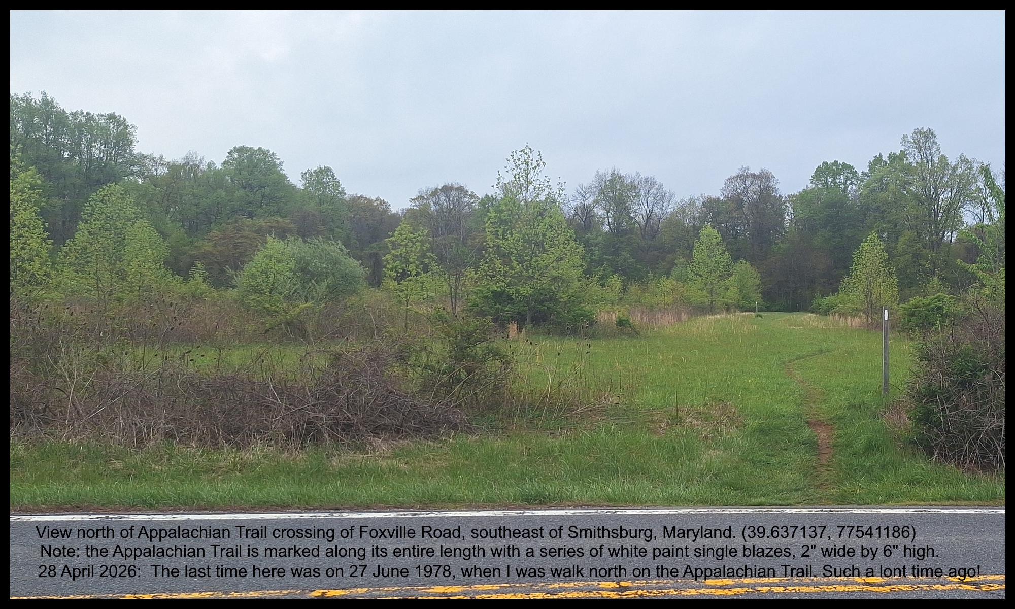
The Appalachian Trail
in Maryland
(m6fo-md-at-2026.0428.1806) Do you see all three white trail blazes.
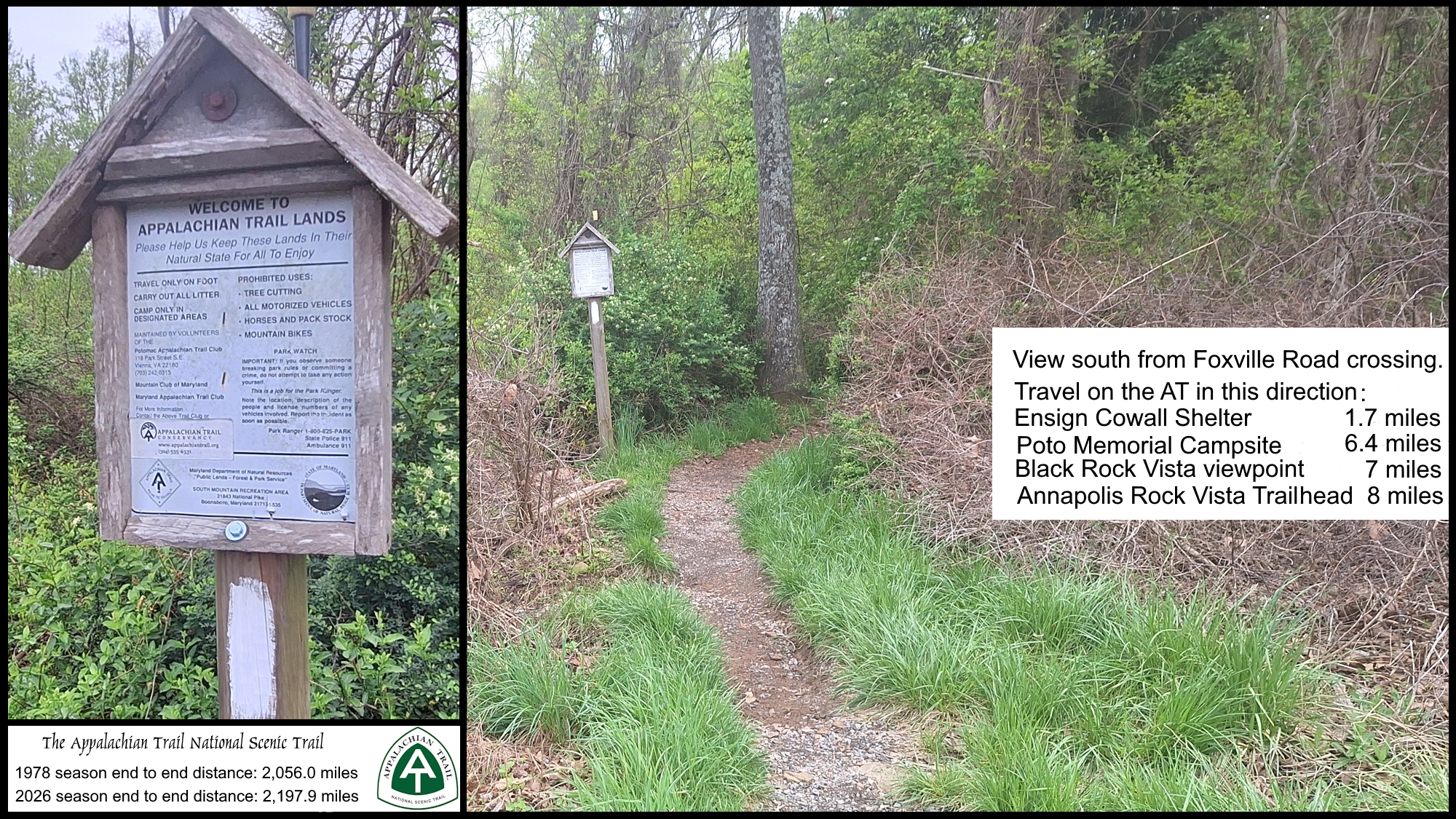
The Appalachian Trail
in Maryland
Well, on my most recent journey here in Maryland, I have come to learn that the hard surface road is now known as Maryland State Highway 77 and locally as the Foxville Road.
Pen Mar Pavilion
Leaving the Appalachian Trail on Foxville Road I driver further east until I arrive at Catoctin Mountain Park, turn left through the entrance and drive mostly north through the park and eventually exit the park onto Raven Rock Road (Maryland SH 491) then left at Fort Ritchie Road, past the former Fort Richie (US Army Intelligence and Communications base, established in 1926 and decommissioned in 1998).
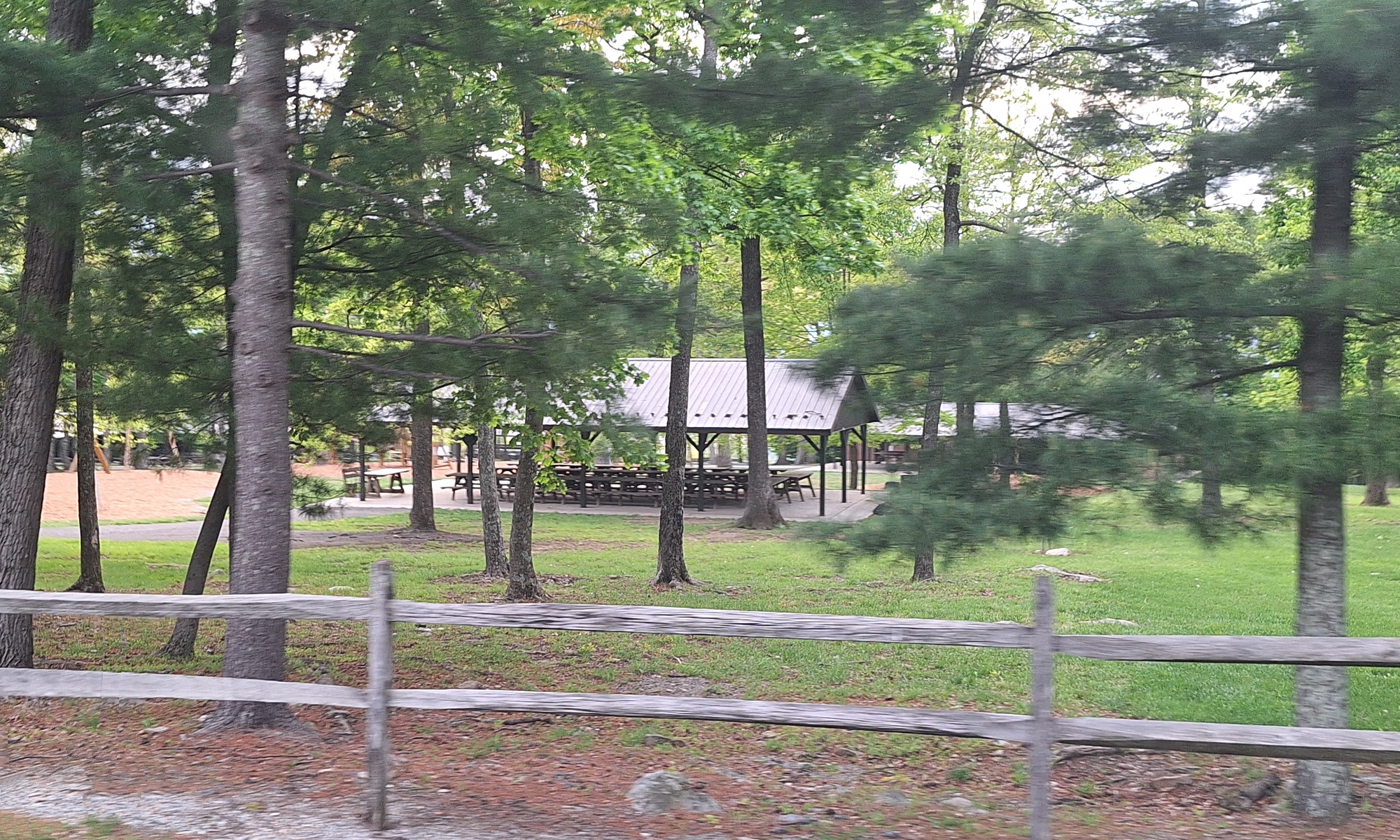
Next, I turn left on Pen Mar Road, alongside the Lake Royal dam, then drive to and through Pen Mar Par during which, I see the Pavilion and take a few photos. The last time I was here was on 27 June 1978, arriving "at the pavilion only moments before thunderstorm lets go of its deluge."
The Appalachian Trail: Maryland
 2026, Pen Mar Pavilion
Mason-Dixon Line
The Mason-Dixon Line, is a demarcation separating four US states: Pennsylvania, Maryland, Delaware and West Viginia, surveyed beginning in 1763, established the Maryland-Pennsylvania boundary, then it was halted by the Indian Wars in 1767, but resumed in 1782 and completed in 1784. This line later came to be known as the boundary between the southern slave states and the northern free states, which demarcation disputes resurfaced during the American Civil Way, with border states becoming key figures in the dispute.
The Confederate States of America claimed the Virginian portion (now West Virginia) portion south and west of the line as part of its northern border, although Virginia never exercised meaningful control that far north, especially after West Virginia separated from Virginia and joined the Union as a separate state in 1863.

"Now the path remaining in Maryland is about one kilometer short of the Mason-Dixon Line (Day 80, 27.1 km)
"So, tomorrow, bring on Pennsylvania and another notch too."
A foot note to the above states: Maryland-Pennsylvania state line at milepost 91, erected in 1767.
28 June 1978, PenMar Pavilion, MD.
(Day 81 AT) 63°F. 6:50 am
23.1 kilometers
PEN MAR PAVILION, A LARGE OPEN structure has picnic tables scattered beneath its massive purlins and rafters.
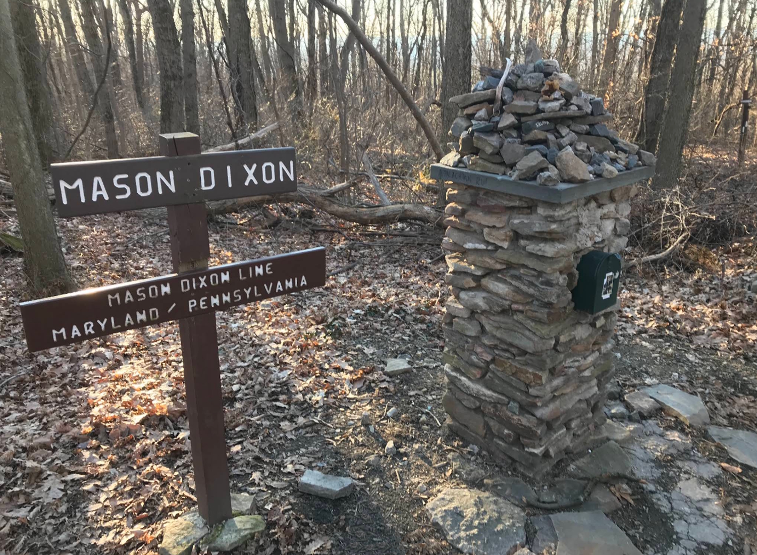
Afoot on the path now and soon come across the Mason-Dixon Line near milestone 91, cross into Pennsylvania and soon afterwards my footfalls enter Michaux State Forest.
The Wayfarers Journal, Episode One: Journey to Katahdin, by Tommy Michel
Excerpts from pages 186-187
The Appalachian Trail: Maryland
 2026, Mason-Dixon Monument at AT
(m6fo-md-at-2026.0428.1907) Mason-Dixon Monument at AT

The 1978 Journey, Appalachian Trail in Maryland Go Down Go Up
The Wayfarers Journal, Episode One: Journey to Katahdin, by Tommy Michel
Excerpts from pages 181
"ABRUPTLY AWAKENED BY A COCKCROW bursting throughout the morning and then find myself startled at seeing the four walls encompassing me with one window facing the sunrise. Suddenly, the self realizes where it lies awakening."
Saturday, 24 July 1978, AT, Maryland.
(Day O77 AT) 65°F.
Day One in Maryland
American Youth Hostel
Up now to eat breakfast and afterwards do laundry. Then it is off to Harpers Ferry for my mail stop. The walk is hot and humid but still make it to the town center well before noon and as the noon siren blares, enter into a grocery to buy an apple, a large bag of cherries and a carton of orange juice for lunch.
There are many tourists here, a large flock of them, and despite the madness, still meet several of the friendly local folks. Arrive at the post office to pick up my surplus gear box, my box of tea, the second food box from Virginia Beach and several letters
Drop my stack of outbound letters into the mail slot and after exchanging several items in the surplus gear box, send it north bound to Palmerton, PA. After stuffing everything else into my day pack, finally head for the ATC office to sign the register.

To go back to the Gallery Index, click on the down arrow. Go back to the
Gallery Index Go to previous section
on this page

Thank you for visiting The Wayƒarers Journal.

See Ya above the Treeline!

This Page Last Updated: 31 May 2026


To continue to the next Episode Level page, Click here go to top
 
The Wayƒarers Journal © ::: Come Join the Journey ™
by Thom Buras
Come Join the Journey ™




