|
Muddy River Route
(Day 129 JO) 60°F. Sunrise: 05:25; set: 20:58
Viento State Park, # A-45 CRS: 5.0
Up at daybreak, take a shower, begin driving and in a short ways to the west arrive at the Bridge of the Gods, pay my dollar toll to cross into Washington, turn east on SR14, drive to Stevenson and stop for breakfast.


(m2vo-wa-saint-2013-0707.0741) Crossing the Columbia River, Bridge of the Gods

(m2vo-wa-saint-2013-0707.0817) Wind River Highway, National Forest Road 30
After my meal, I continue east on SH 14, then turn north on NF-30 following the Wind river and travel thirty mile to where it intersects with NF-90.
McClellan Viewpoint
Here, I stop at the McClellan Viewpoint to read the information board. This viewpoint is on the southeast side of the volcano and fairly close to it but the volcano is not visible from here.
From the McClellan Viewpoint I drive west on NF-90 and in about two miles come to the intersection of NF-25. After passing the Eagle Cliff store, I turn north on NF-25, drive past a picnic area and travel up NF-25 in the forest on the east side of the volcano looking for more viewpoint.
Soon, I come to a sign stating Muddy River Viewpoint where I pull over at a picnic area and find my first good view of the volcano.

(m2vo-wa-saint-2013-0707.0929) Mount Saint Helens, Muddy River Viewpoint

(m2vo-wa-saint-2013-0707.0931) Mount Saint Helens, Muddy River Viewpoint
I drive on and then find an even better viewpoint, one which has a view of the north side of the mountain showing the area missing from the blast.
Clearwater Viewpoint
What a clear sky during the drive on this forest road route and get some great shots of the volcano.

(m2vo-wa-saint-2013-0707.1001) Mount Saint Helens, Clearwater Viewpoint
Driving north on NF-25 brings me to my next intersection, where I turn west on NF-99 and travel only a few miles before I enter the blast zone.
1
The route now shows clear evidence of the devestation caused by the eruption as everywhere the forest is devoid of trees. Soon, I arrive at Bear Meadow and stop briefly for more photos.

(m2vo-wa-saint-2013-0707.1020) Mount Saint Helens, Entering the Blast Zone
Bear Meadow Viewpoint
Bear Meadow, eleven miles northeast of Mount Saint Helens, is the location where Gary Rosenquist and friends camped on the night before the eruption. At eight twenty-seven the next morning, he took what proved to be the last pre-eruption photograph of the mountain. Then, he took 22 photographs of the colossal landslide, unprecedented lateral blast and eruption before fleeing for his life.

(m2vo-wa-saint-2013-0707.1010) Mount Saint Helens, View from Bear Meadow
I continue west on NF-99, coming closer and closer to the volcano, stopping often for photos as the roadway winds back and forth through the
treebare forest.

(m2vo-wa-saint-2013-0707.1012) Mount Saint Helens, Approaching Windy Ridge

(m2vo-wa-saint-2013-0707.1028) Mount Saint Helens, Approaching Windy Ridge
The Total Devastation
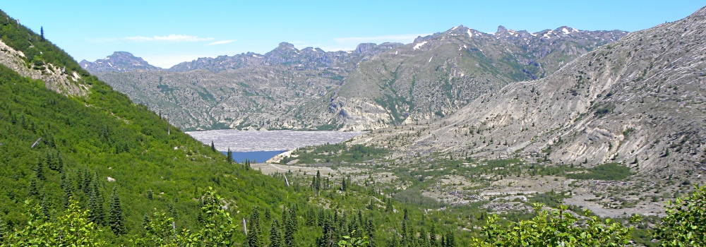
Suddenly, I catch a fleeting glimpse of blue water which happend so fast that I have to turn around and return to the view to confirm what I had seen. Yes, it is my very first glimpse of Spirit Lake. I grab my camera to record this moment as I know this will prove to be a photo that I will want to return to examine again, even one that I could share.
Sitting down, I contemplate about what lies before me. The nearby mountain steep is now green with new growth and even a few scattered trees, but most of the mountain surrounding Spirit Lake is still gray and remains mostly treebare.
I know that plant and animal life is tenacious and in most disasters, will return back to a condition similar to before the diaster in just a few decades, but the devastation here from the volcanic eruption seems to be persisting, even longer that I would have imagined it to have.

(m2vo-wa-saint-2013-0707.1031) Mount Saint Helens, First View of Spirit Lake
These gray areas, totally forested before 18 May 1980, lie in the direct lateral blast zone from the volcano. It has been thirty-three years and almost two months since the eruption and still, the mountain looks barely recovered.
Then, using my camera, I zoom in on the water surface and in a total stupor, cannot believe what I am seeing. A large part of the visible surface of the water is still covered with a bog of floating trees left there from the eruption. Methinks, my mind is just not able to grasp the immensity of devastation that occurred here.
I gather my things, return to the jammer and while thinking deeply about the things I have just seen, continue along the roadway towards the next viewpoint.
Cedar Creek Viewpoint
As I come closer to the volcano, I am seeing up close how much devastation did actually happen. Everything was leveled to the ground in the blast zone, even on the seemingly protected back sides of ridges.
The pyroclastic flows of gas, ash and pumices rolled over the ridges and leveled everything, nothing could hide for the liquid like flows.

(m2vo-wa-saint-2013-0707.1031) Mount Saint Helens, Cedar Creek Viewpoint

(m2vo-wa-saint-2013-0707.1035) Mount Saint Helens, Cedar Creek Viewpoint
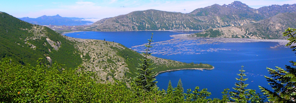
Spirit Lake
Spirit Lake is remembered by many when it was a beautiful lake of crystal clear, icy water, one that had snow covered Mount Saint Helens towering above and which had boat docks, campgrounds, lodges, log cabins, mountain climbing bivouacs, ranger station, scout camps and snowplay areas, all nestled among old growth firs lining the twelve mile lake shoreline. Yes, it was a place many people considered a paradise, who came to enjoy the simplicity, solace and solitude that could be found in the surrounding forest, mountain, waters and wilderness.
In 1985, in order to maintain a safe level of Spirit lake and prevent a breach of the new volcanic ash dam and a resulting catastrophic flooding of Toutle river valley, a 8465 foot gravity-feed tunnel was cut through Harrys ridge and has since been used to maintain the water level of Spirit Lake at about 3,400 feet.

(m2vo-wa-saint-2013-0707.1036) Mount Saint Helens, Spirit Lake
Then, in just a matter of moments, the May 18th eruption destroyed everything forever. The landslide from the eruption plunged into Spirit Lake, raising the lake′s surface two hundred feet and submerged the camps, cabins, lodges, in fact, all manmade structures; nothing survived except the lake and the mountain, but even these were changed forever.
Donnybrook Viewpoint

(m2vo-wa-saint-2013-0707.1042) Mount Saint Helens, Donnybrook Viewpoint

(m2vo-wa-saint-2013-0707.1047) Mount Saint Helens, Donnybrook Viewpoint
From this viewpoint, I begin to see the growing lava dome inside the volcano′s crater, currently at 7000 feet elevation. From what I learned at the Johnston Observatory, the cone has grown over a thousand feet from small eruptions in the years following to the explosion.
Returning to the jammer, I continue on NF-99
| 


